
Abstract
In Sri Lanka, the decision to approve land-filling proposals is primarily based on a parcel being placed on a zoning category, and the setback distance and hazard maps at the city or basin scale. What they don’t often ask is more relevant and more useful: What does the filling of this particular parcel do to the neighbors? The transfer of flood risk to surrounding lands as a consequence of land development in flood-prone lowlands has been documented, and the specification of imperviousness and drainage connectivity at the parcel scale influences flood behaviour in isolation of the flood zone in which the parcel is located. The same can be observed in the City of Gampaha, northeast of Colombo, where the growth of this urban district is equally rapid: when the effects of raising individual parcels are calculated over the adjacent land, varying exposures are found, and parcels that have been identified by the composite risk label could be exposed to flood risk for different reasons in reality, and a significant proportion of parcels within the city’s identified low-lying flood zone are in fact only moderately or less exposed to these risks. But this is not reflected in the way development applications are assessed at the present time. Not all flood risk data is a data problem because it can be determined as a zone-level property instead of a parcel-level property. It’s a governance decision to allow risk to slowly migrate from one landowner to another, and it’s a costly one.
Keywords: flood risk transfer, land filling, parcel-scale assessment, development approval, urban flood governance, Sri Lanka
Viewpoint
The Question Approval Processes Don’t Ask
The question that most often gets asked to a development authority in Sri Lanka when they are looking at an approval application is invariably a question relating to that plot by itself. Does it fall within a flood hazard area on the hazard map. Is it located at the setback required? Does the proposed elevation meet some regulatory requirement? It doesn’t ask in any systematic way what filling this particular parcel might do to the adjacent parcels.
An Externality, Not a Technical Detail
Flood elevation does not simply occur on top of a landfill, but affects the way water flows over land that was previously draining across it. In a case study of land development in flood-prone lowlands, Yang et al. (2018) explain that raising one parcel above the flood level will not remove the flood risk, but will shift it to neighbouring land where the flood intensity will be exacerbated. Those people who are going to gain from a fill are not the ones who are taking the extra risk. The mechanism is shown in figure 1. This is textbook externalities and one piece of land at a time, largely in the absence of planning systems designed to assess flood risk.
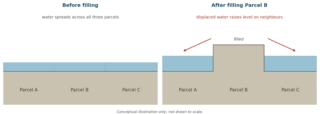
Figure 1. How filling one parcel can move flood risk onto its neighbours (conceptual illustration)
This is supported by the broader literature on parcel-scale flooding. Berndtsson et al. (2019) recognise that flood behaviour at the parcel level is the result of an interacting set of factors, such as land use, topography, soil type and drainage connectivity, that do not map cleanly onto the coarser zones used in most flood hazard maps. Mahmoud and Gan (2018) demonstrate that the creation of impervious surfaces along parcels of land decreases infiltration and increases surface runoff, as development progresses. Slavíková and Milman (2025) note that the actions of grading, embankment and drainage rerouting that can be undertaken for purposes of flood mitigation can create their own localised risk, such as water stagnation, or changed flood inundation downstream, because their effects are assessed on the site, not at the neighbourhood level. This published evidence is summarised in Table 1. This is not unusual. It is proven to be well-known. What’s missing is a regulatory process designed to take action on it.
Table 1. Published evidence on land modification and parcel-scale flood risk.
| Source | Focus | Relevant finding |
| Yang et al. (2018) | Land development in flood-prone lowlands | Raising a site above flood level transfers flood risk onto surrounding land |
| Berndtsson et al. (2019) | Drivers of urban flood risk | Parcel-level flood behaviour depends on land use, topography, soil type and drainage connectivity |
| Mahmoud & Gan (2018) | Urbanisation and flood susceptibility | Converting permeable land to impervious surface reduces infiltration and increases runoff |
| Slavíková & Milman (2025) | Land modifications for flood mitigation | Mitigation-oriented modifications can create new, localised risks such as water stagnation |
| Dash & Sar (2020) | GIS-based flood hazard assessment | Parcel-level data improves identification of vulnerable, modified land compared with zone-level data |
What Fieldwork in Gampaha Adds
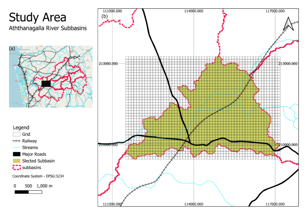
Figure 2. Location of the study area within Gampaha Municipal Council, Sri Lanka
For the last two years, I have been studying land-filling trends and flood behaviour in Gampaha City, a rapidly urbanising municipal area located northeast of Colombo where there have been several occasions of severe flooding (Figure 2). I tried this out using a calibrated hydraulic model of the area, using what should happen if each of the parcels I know is a flood hazard when I fill it in a bit to see if the pattern of flooding changes compared to the original terrain. This did not yield a consistent pattern. A few adjacent lots experienced an increase in flood exposure due to a fill constructed close to the parcel; other lots experienced little change, or even an improvement. In other words, flood risk wasn’t a quality of the neighbourhood or the flood zone that the parcel was located within. It was a characteristic of the parcel and unique to the particular parcel’s location within the local drainage network.
There was a little more complexity when looking at the parcel-level risk classifications of the model. Not all parcels in the same composite risk category were at that risk because of the same risk. Sometimes high risk was due to water being really concentrated there. In other watersheds, the amount of impervious surface, roads and rooftops, was the primary driver of the watershed being in the same risk category as it was without vegetation. While both situations require different courses of action (one involves controlling water accumulation, the other involves controlling water runoff), a single risk label won’t distinguish between them.
The most significant discovery was that the city’s low-lying flood zone—its most heavily used designation for development that’s been rejected by the city—was not an accurate description of the city’s condition. When the true flood risk and land uses of the parcels within that area were evaluated directly after they were mapped, a significant portion of those parcels were found to have moderate or low flood risk. The fact that a parcel is located in a low lying area, by itself, is an indicator of flood risk, and for a significant number of parcels, it is an overestimate. An approval process based primarily on the zone is almost certainly turning down some applications that are not a true flood hazard, and accepting others, both within and outside of the zone, which have an unmeasured impact on neighbor property.
Where Zoning Succeeds, and Where It Stops
None of this is a reflection of the people that are doing the zoning. The research elsewhere in Sri Lanka demonstrates that zoning can be carried out well in Sri Lanka; on the Lower Kelani River floodplain, Iresh et al. (2024); on the integrated flood vulnerability modelling in Neluwa, Wijesinghe et al. (2023); and on the classification of flood risk using GIS and remote sensing, Asare-Kyei et al. (2015). However, this scale is still a sub-district or catchment scale – and even a good zoning system of this type does not go so far as to ask, ‘what does this approval do to the neighbouring parcel?’. A parcel can meet all the requirements of a well-designed zoning system and yet impose a real flood upon its neighbour, and no one will be called upon to notice.
Similarly, Dash and Sar (2020) note that zone-based data masks the actual variability of land in different locations, and that the inclusion of parcel-level information into flood hazard assessment using GIS greatly enhances the identification of the vulnerable and modified land. In practice, the Gampaha fieldwork indicates that this is indeed the case. Assessment at the aggregated, zone level is not being performed poorly. It is answering the wrong question as to who the next land owner is that will be flooded.
Table 2. Zone-level and parcel-level flood assessment compared (conceptual).
| Aspect | Zone-level assessment | Parcel-level assessment |
| Unit of analysis | Sub-district, catchment or mapped flood zone | Individual parcel and its immediate neighbours |
| Question answered | Is this site inside a hazard zone? | What does modifying this site do to the parcels around it? |
| Effect on neighbours | Not assessed | Central to the assessment |
| Cause of risk | Usually a single composite label | Can distinguish water accumulation from impervious runoff |
| Role in approval | Basis for approval or rejection | Screening step alongside zoning, with graduated responses |
Closing the Gap: A Parcel-Level Screening Layer
Here lies the governance gap and it is easily fixable. Development authorities need not have a completely new hazard map. One more, narrower question they should ask themselves in the approval process: How would the filling of this parcel affect the surrounding existing or proposed land uses, particularly in the surrounding drainage system? Answering that doesn’t involve re-running a full flood model for each application. There is a practical output indicated by parcel-level assessment methods already available in the literature: GIS-based classification (Asare-Kyei et al., 2015) and the hydrodynamic modelling and parcel data approach (Dash & Sar, 2020), which is a screening layer created once for a jurisdiction to flag proposals that are likely to transfer risk to neighbouring land prior to approval.
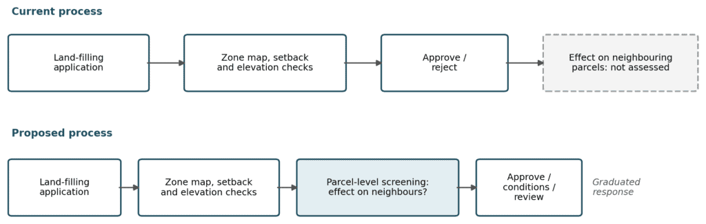
Figure 3. Current approval process compared with a process including a parcel-level screening step.
This would be less a new layer of bureaucracy and more a reference data set which planning officers should consult because they already have a reason for doing so. Once constructed, it could be added to the zone map and elevation rules without any changes, except for a one additional check: does granting this parcel’s development increase measurable risk to the neighbouring properties? “Yes” doesn’t automatically mean “no.” It might be a mitigation condition, a compensatory drainage obligation or a flag for closer scrutiny, just like they do with other site-specific risks in a graduated response planning system. What it shouldn’t mean is silence, the normal result of the present process.
Beyond Gampaha
The implications are bigger than Gampaha. In the fast urbanising regions of the Global South, the provision of formal drainage infrastructure is often lagging development – and this is matched by under-resourced planning agencies, which have the coarsest of hazard tools available to them, and which are often used in micro-scale land fillings, prior to formal drainage upgrade. This mismatch, such as approval frameworks designed to cover scale of the zone and applied to a decision at the parcel level, is likely to be repeated wherever land filling continues parcel by parcel without flood governance. Gampaha is a case study, not a special case.
The Cost of Waiting
Leaving this gap requires not just a cost, but an actual cost. It appears as flooding on unfilled lands, on lands that were never developed and that no one actually intended to develop, lands whose only contact with it was to occupy space adjacent to another person’s development. In an area that has been on a steady development ramp up, that expense is added to each successive approval that clears the present set of rules, but not the one that matters in determining who’s taking the risk.
Over the past decade the modelling of flood risk at both the basin scale and the city scale has improved significantly – and it has. Urban development occurs in lots of parcels and a flood governance framework that continues to assess at a scale that is too broad to detect the parcel will continue to allow the gap between what’s approved and what floods to widen. There are techniques in place to close this gap. The problem is not the method. The mandate is a requirement that has been inserted into the approval process itself: an application for landfill must be evaluated not as a standalone site but with regard to the effect it will have on adjacent sites.
References
Asare-Kyei, D., Forkuor, G., & Venus, V. (2015). Modeling flood hazard zones at the sub-district level with the rational model integrated with GIS and remote sensing approaches. Water, 7(7), 3531–3564. https://doi.org/10.3390/w7073531
Berndtsson, R., Becker, P., Persson, A., Aspegren, H., Haghighatafshar, S., Jönsson, K., Larsson, R., Mobini, S., Mottaghi, M., Nilsson, J., Nordström, J., Pilesjö, P., Scholz, M., Sternudd, C., Sörensen, J., & Tussupova, K. (2019). Drivers of changing urban flood risk: A framework for action. Journal of Environmental Management, 240, 47–56. https://doi.org/10.1016/j.jenvman.2019.03.094
Dash, P., & Sar, J. (2020). Identification and validation of potential flood hazard area using GIS-based multi-criteria analysis and satellite data-derived water index. Journal of Flood Risk Management, 13(3). https://doi.org/10.1111/jfr3.12620
Iresh, A. D. S., Athapattu, B. C. L., Obeysekera, J., & Fernando, W. C. D. K. (2024). Floodplain zoning and mapping for lower Kelani River, Sri Lanka. Engineer: Journal of the Institution of Engineers, Sri Lanka, 57(3), 23–33. https://doi.org/10.4038/engineer.v57i3.7594
Mahmoud, S. H., & Gan, T. Y. (2018). Urbanization and climate change implications in flood risk management: Developing an efficient decision support system for flood susceptibility mapping. Science of the Total Environment, 636, 152–167. https://doi.org/10.1016/j.scitotenv.2018.04.282
Slavíková, L., & Milman, A. (2025). Mitigation of concurrent flood and drought risks through land modifications: Potential and perspectives of land users. Annual Review of Environment and Resources, 50, 25. https://doi.org/10.1146/annurev-environ-110922
Wijesinghe, W. M. D. C., Mishra, P. K., Tripathi, S., Abdelrahman, K., Tiwari, A., & Fnais, M. S. (2023). Integrated flood hazard vulnerability modeling of Neluwa (Sri Lanka) using analytical hierarchy process and geospatial techniques. Water, 15(6). https://doi.org/10.3390/w15061212
Yang, S. Y., Chan, M. H., Chang, C. H., & Hsu, C. T. (2018). A case study of flood risk transfer effect caused by land development in flood-prone lowlands. Natural Hazards, 91(3), 863–878. https://doi.org/10.1007/s11069-017-3130-x